10:45 AM | Hottest August ever...not so fast according to satellite observations
Paul Dorian
Discussion
Overview NASA’s Goddard Institute of Space Studies (GISS) released a report earlier this week suggesting that August was the hottest August ever recorded on a global basis in its 134 years of record keeping dating back to the year 1880 (actually the initial report was quickly revised by NASA making it the second hottest August ever in their dataset). The global temperature anomaly map (below) from NASA displays the global temperature anomalies for August 2014 versus the 1981-2010 averages with the overall anomaly calculated at +0.31°C. The “yellow/orange/red” areas on the map represent those areas with temperatures above the 1981-2010 averages and the “blue/purple” regions experienced below average temperatures. Other datasets, however, which rely primarily on satellite observations for temperatures as compared to thermometer-based measurements, show a strikingly different story with respect to where August 2014 stands historically in terms of August global temperature anomalies.
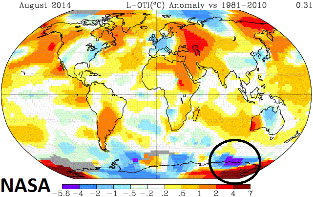 [NASA global temperature anomalies for August 2014]
NASA’s GCHN and ERSST dataset and some known problems The NASA global land and ocean temperature anomalies are a merged product of the Global Historical Climatology Network (GCHN) which relies on ground-level thermometer-based temperature measurements from 6000 weather stations around the world and the Extended Reconstructed Sea Surface Temperatures (ERSST) for ocean temperatures. There are some known problems associated with thermometer-based datasets that include poor data coverage in significant portions of the polar regions and also the need for data “adjustments” at many weather stations in order to eliminate urban heat island (UHI) effects.
Data Sparse regions An important problem related to thermometer-based temperature measurements around the world is that there are several sparse data regions located away from developed countries, which are concentrated on the land masses and in the northern hemisphere mid-latitudes. While these developed areas have a dense network of weather stations, temperature monitoring equipment is scarce in some parts of the Amazon, Africa, Antarctica, and Arctic. In the Arctic, particularly, the absence of solid land means there are large areas without weather stations. NASA addresses this problem by “filling” in the gaps with data from the nearest land stations, up to a distance of 1200 kilometers (746 miles) away. In this way, the NASA analysis achieves near total coverage in the Arctic. This approach by NASA may either overestimate or underestimate Arctic warming and the same concerns hold true for Antarctica and the other data sparse regions. Indeed, NASA scientists suggest "there's no doubt that estimates of Arctic warming are uncertain, and should be regarded with caution," when describing this particular approach of “in-filling” (http://www.giss.nasa.gov/research/news/20110113/).
For the month of August, this “in-filling” of data by NASA in the large data sparse region of Antarctica resulted in an area of very high temperature anomalies – in fact, the highest “relative-to-normal” temperatures (4-7°C) seen anywhere across the globe – and this could be an overestimate of the warming in that region; especially, given the fact that sea ice areal extent surrounding the continent expanded to or near record levels almost on a daily basis throughout the month (http://arctic.atmos.uiuc.edu/cryosphere/antarctic.sea.ice.interactive.html; yellow curve on plot represents 2014). Also, in this data sparse region of Antarctica, there exists the somewhat unlikely scenario of the month’s coldest temperature anomaly (purple region) in close proximity to the just described warmest anomaly (circled area on map). One final note with respect to data sparse regions, NOAA’s National Climatic Data Center (NCDC) uses this same GCHN dataset for historical global monthly temperature comparisons and they do not use this “in-filling” approach, but simply keep areas that have no data coverage as “missing data” regions in their calculations resulting in large portions around the world not having any impact on the monthly global temperature anomaly.
Urban Heat Island effects In addition to the problem of data sparse regions for thermometer-based temperature measurements around the world, there is the added problem of urban heat island (UHI) effects that presents difficulties in historical temperature comparisons. In numerous weather station locations, the local surrounding areas have changed dramatically over time from rural to urban-like (i.e., more asphalt, concrete) and this change is known to have an important “artificial warming” effect on overall temperatures. The biggest “artificial warming” impact from UHI effects is during nighttime hours when winds are relatively weak and materials such as concrete and asphalt act to slow down the cooling process. It is important to eliminate UHI effects from thermometer-based datasets used for historical temperature comparisons in order to accurately evaluate climatic trends. As a result, NASA applies “adjustments” to numerous urban and near-urban weather stations within the GCHN dataset in order to minimize or eliminate these UHI effects (http://data.giss.nasa.gov/gistemp/). Applying the correct “adjustments” to thermometer-based temperature measurements is a difficult task taken on by NASA (and NOAA) in order to reduce or eliminate urban heat island effects. Many complex questions must be answered such as “what is the correct magnitude for the “adjustment”, how far away from urban stations do “adjustments” need to be made, and “how do you change the “adjustments” for a particular location from decade-to-decade (Las Vegas and Phoenix, for example, changed significantly from the 1930’s to the 1960’s to the 1990’s). (For more information on UHI effects visit http://en.wikipedia.org/wiki/Urban_heat_island).
Satellite observations of lower tropospheric temperatures In today’s world, approximately 99% of all observations used in weather and climate analysis come from remote sensing techniques and primarily from satellites. Satellite measurements of the Earth’s microwave emissions are a crucial element in the development of an accurate system for long-term monitoring of atmospheric temperature. Special sensors (microwave sounding units) aboard satellites have orbited the Earth since the late 1970’s allowing scientists to calculate temperatures of the atmosphere in the lower troposphere. While satellite observations are not without some of their own limitations, they provide nearly complete global coverage and homogeneous data quality at much higher densities than attainable with in situ observations. In situ observations also suffer from non-uniform temporal coverage and undocumented changes in the instrumentation used that can lead to local biases and increased uncertainty. Finally, satellite-derived temperatures don’t require the “UHI adjustments” often required with conventional weather station temperature measurements.
UAH and RSS – two temperature datasets that rely on satellite observations Two datasets that rely on satellite observations for lower tropospheric temperatures include the UAH and RSS. The record-keeping for these two datasets goes back to 1979, which is when the satellite-observations data-keeping era began. The UAH is a product of the Earth System Science Center of the University of Alabama in Huntsville (UAH) and has relied on the NASA Aqua AMSU satellite in recent years. The UAH lower troposphere temperature data are for latitudes of 85°S to 85°N which represents more than 99% of the surface of the globe. The UAH results for the month of August in terms of where it stands historically were noticeably different than NASA’s findings. Specifically, the UAH lower troposphere global temperature anomaly for August 2014 was calculated at +0.20°C and there are seven hotter Augusts compared to this year in just the 35 years of data going back to 1979. (For more information on UAH data: http://nsstc.uah.edu/climate/).
Like the UAH lower troposphere temperature data, Remote Sensing Systems (RSS) calculates lower troposphere temperature anomalies from microwave sounding units which, in this case, are aboard a series of NOAA polar-orbiting satellites. The RSS lower troposphere temperature data are for latitudes of 70°S to 82.5°N. The RSS results for August global temperature anomalies are dramatically different than NASA’s findings. The RSS lower troposphere global temperature anomaly for August 2014 was calculated at +0.193°C and there are thirteen hotter Augusts in the 35 years of data going back to 1979. In fact, while still above normal compared to the base period 1981-2010, RSS data shows August 2014 to be the 7th coolest August since 1995. (For more information on RSS data: http://www.remss.com/missions/amsu/).
The complete record for the RSS, UAH and NASA global temperature anomalies for each and every August going back to the year 1979 is presented in Table 1 (below) using 1981-2010 as the base period for comparison.
Table 1: August global temperature anomalies (°C) where “bold, red” indicates those previous Augusts that were hotter than this August

[RSS, UAH, NASA: using base period for comparison of 1981-2010]
RSS data (courtesy Remote Sensing Systems): http://data.remss.com/msu/monthly_time_series/RSS_Monthly_MSU_AMSU_Channel_TLT_Anomalies_Land_and_Ocean_v03_3.txt
UAH data (courtesy Dr. Roy Spencer, Dr. John Christy and University of Alabama at Huntsville): http://www.nsstc.uah.edu/data/msu/t2lt/uahncdc_lt_5.6.txt
NASA data using GHCN-v3 1880-08/2014 + SST: ERSST 1880-08/2014: http://data.giss.nasa.gov/gistemp/maps/