9:00 AM | **Mid-winter update...cold pattern to continue and snow is sure to follow**
Paul Dorian
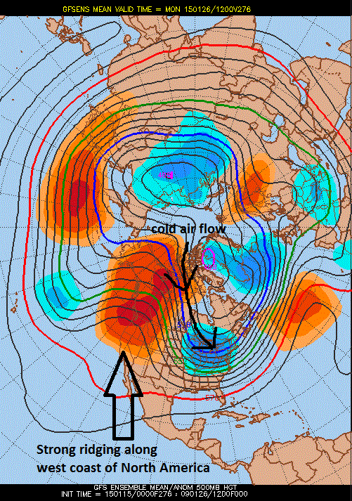 [00Z GFS Ensemble forecast map of 500 millibar height anomalies late this month; map courtesy Penn State eWall]
Discussion
Overview The first half of January has been colder-than-normal in much of the Mid-Atlantic region and indications are quite strong that the cold weather pattern will continue around here for the latter part of January and perhaps for much of February as well. In fact, there is reason to believe that the cold - relative to normal - could actually get much worse during the latter part of January and into early February compared to what we've experienced recently. So far this month, temperatures have averaged 3.5°F below normal at Philly International Airport in South Philadelphia, 3.7°F below normal in Central Park, New York, and 5.6°F below normal at Dulles Airport in Virginia. In addition, the colder-than-normal weather this month has extended across much of the eastern two/thirds of the nation and it is entirely possible that the nation as a whole ends up colder than last January which certainly was well below normal and made famous for its “polar vortex cold”. Snow, on the other hand, has been somewhat sporadic in the Mid-Atlantic region so far; however, sea surface temperature anomalies in both the Pacific and Atlantic Oceans - combined with the cold temperature outlook - suggest significant snowfall amounts are still possible as we progress through the second half of the winter season.
Temperatures and the connection to the 500 millibar height anomaly pattern There is reason to believe that a strong ridge will re-form along the west coast of North America as we progress into the latter part of January. Indeed, the forecast map (above) from last night's 00Z GFS Ensemble run for later this month features strong ridging (oranges) along the west coasts of Canada and the US and this type of pattern usually leads to multiple Arctic air mass incursions into the northern US from northern Canada. In fact, this forecast map suggests that the upper-level winds at 500 millibars – which tend to follow the height anomaly lines - could actually bring air from right around the North Pole into the northern US later this month.
Snowfall and the connection to sea surface temperature (SST) anomalies Snow has been rather sporadic so far this winter in the Mid-Atlantic region, but two far apart sea surface temperature patterns suggest significant snow is still on the table for the second half of the winter season. First, the latest SST anomaly map (below) shows some well-above normal sea surface temperatures near the US east coast (reds, oranges, yellows). Historically, this type of pattern with warmer-than-normal water off the US east coast has been linked with above-normal snowfall in the Northeast US during the second half of the winter season. Warmer-than-normal water just off the US east coast in the wintertime tends to help increase the temperature gradient along the coastline, decrease the stability of the lower atmosphere, and, in general, helps to intensify coastal storms.
In addition, the latest SST anomaly pattern in the central Pacific Ocean features an El Nino (warmer-than-normal; yellows, oranges) and this has often been correlated with above-normal snowfall during the latter half of winter seasons in this part of the country. As an example, the El Nino winter of 1982-1983, which featured little snowfall during the first half of winter, produced a blockbuster snowstorm in the Northeast US during February of that particular winter.
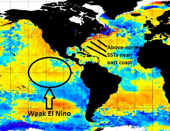 [Current sea surface temperature anomaly chart; courtesy NOAA]