10:00 AM | *****Major disruptive snowstorm potential from Philly-to-Boston later Monday into Tuesday; DC area in the game as well and gets accumulating snow*****
Paul Dorian
Discussion
Overview The potential exists for one of the great all-time nor'easters in the region from New York City/New Jersey-to-Boston. If you have some bare ground on your lawn, you may want to take a good look at it now as it will likely not be visible after today for many, many weeks. There will be accumulating snow over the next 48 hours in the Mid-Atlantic region and it will be subtantial in many areas. In addition, there will be multiple bitter cold Arctic air outbreaks during the next few weeks which will make sure that the snow sticks around for a long, long time. This will be a two-part event with the first part associated with a "clipper" from later tonight into tomorrow afternoon and in this time period any snow that falls can be mixed with rain primarily south of the PA/MD border. Then, energy from this system will feed into a coastal low which will develop explosively later tomorrow and tomorrow night as it heads to the northeast from the Carolina coastline producing snow (no more mixing issues) in the I-95 corridor.
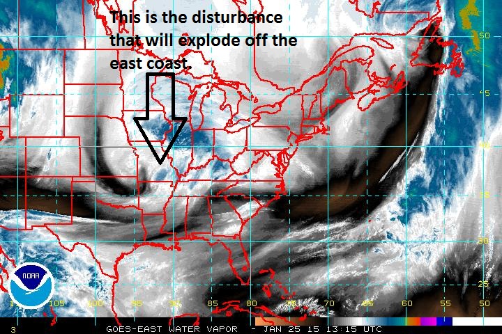
“Clipper” type system Sunday night into Monday afternoon An Arctic front slides through the region today setting the stage for the development of a major coastal storm during the next 48 hours. A “clipper” type of system now over the Mississippi Valley (water vapor image) is moving east-to-southeast today and it will reach the coastal waters of the western Atlantic Ocean by later Monday. Snow will move into the I-95 corridor region tonight, perhaps mixed with rain south of the PA/MD border. Precipitation will become all snow by tomorrow morning and continue into the afternoon. By this time, there can be a few inches of snow in the DC and Philly metro regions with lesser amounts to the north near New York City. The main action, however, begins late tomorrow and early tomorrow night; especially, from Philly and points to the north and east.
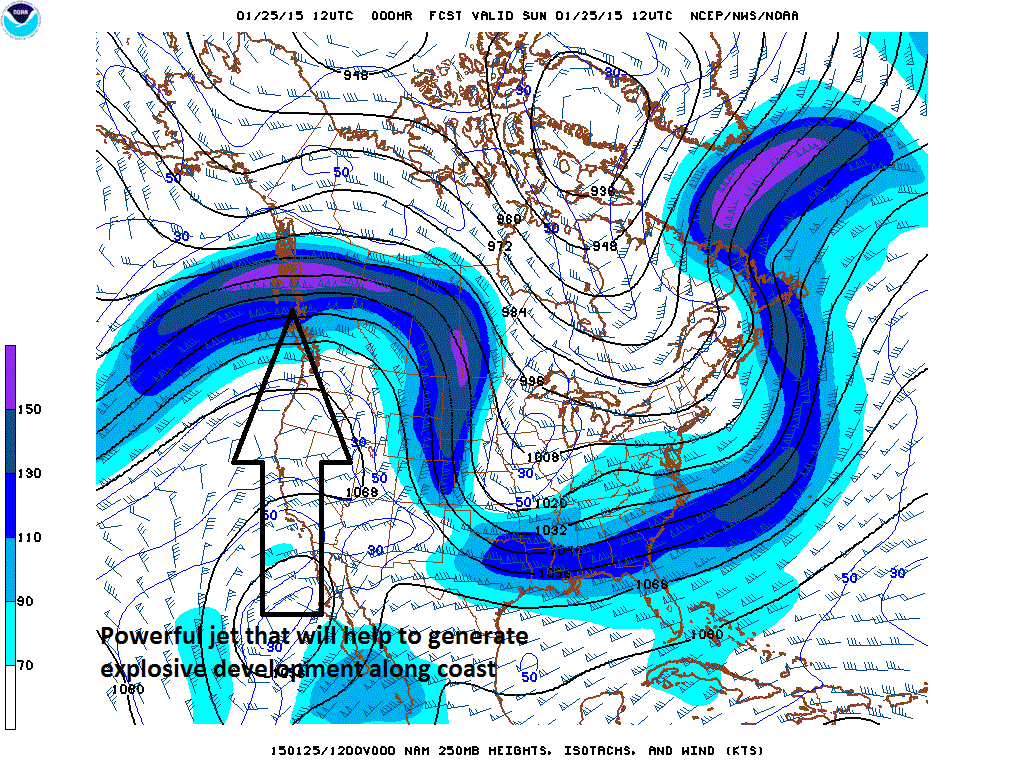
Explosive nor’easter Monday night into Tuesday Once this system reaches the western Atlantic Ocean later tomorrow, the combination of the relatively warm ocean water, a powerful upper-level jet streak (below), and an influx of brutally cold Arctic air from the northwest will cause it to explode off of the Northeast US coastline from later Monday into Tuesday. As a result, snow will intensify by tomorrow night in the I-95 corridor region from Philly northeastward and perhaps even all the way down to the DC metro region. This snow will be of the dry, fluffy variety - not like the wet snow that fell Friday night. This could turn into an all-out blizzard by tomorrow night and Tuesday from Philly northeastward with heavy snow, strong winds and bitter cold. Blizzard conditions are likely in coastal areas from New Jersey northeastward to the New England coastline.
By the time Tuesday morning rolls around, there can be up to 6 inches or more of new snow in DC, a foot or more in Philly region, and 20-30 inches likely from NYC-to-Boston where it looks likely that this storm will be talked about for a long time. One last point, the overall weather pattern looks absolutely frigid for the foreseeable future – perhaps right through February - and there will be multiple snow threats with the next one arriving late Thursday into Friday. The cold shot early next week as we begin the month February could be record-breaking in the Northeast US.