12:50 PM | **Significant snowfall threat continues north of the PA/MD border for late Sunday into Monday...mixed bag possible to the south of there**
Paul Dorian
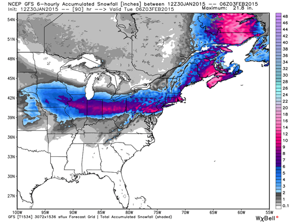 [12Z GFS total snowfall map for the upcoming storm; courtesy Weather Bell Analytics]
Discussion
Copious amounts of moisture will head out of the southwestern states on Saturday and into the central Plains and then continue right towards the Mid-Atlantic region later this weekend. Significant snow is occurring today in the southwest US (e.g., New Mexico) and it’ll move into the region between Kansas and Indiana by tomorrow afternoon. By Sunday, this moisture will begin streaming into the Mid-Atlantic region with cold air place and snow is likely break out during the late afternoon or early evening hours. The low pressure system associated with this moisture is likely to move in a general west-to-east fashion across West Virginia into Virginia and then to the Delmarva Peninsula coastal region by Monday morning. It is unlikely that this track shifts any farther to the north from here given the developing blocking pattern in the upper atmosphere over eastern Canada and southern Greenland. In fact, there is the chance this storm track shifts slightly to the south by the time the event rolls around which would likely increase the chances for more snow south of the PA/MD border. With the current projected storm track, warmer air in lower levels of the atmosphere may cause a changeover from snow to sleet and freezing rain, and perhaps even to plain rain in the region south of the PA/MD border from near DC to southern New Jersey. This would reduce potential snowfall accumulations significantly in that area; however, there still could be up to a few inches at the onset of the storm and then perhaps some more at the end sometime later Monday.
North of the PA/MD border; however, where much of the precipitation is likely to be in the form of snow along with sleet mixed at times, there can be substantial snowfall accumulation amounts. Given the current projected storm track, a general 6-12 inch snowfall is possible from Chicago to Pittsburgh to Philly to NYC and then to Boston. There are still a couple of days to go; however, and a slight shift in the storm track would make a huge difference. No matter what happens with this early week storm regarding snowfall, bitter cold air is likely to follow for much of next week. In fact, there could be record-challenging cold in the Northeast US on Tuesday, Friday and Saturday mornings with one Arctic blast immediately following the storm and then another one late next week. The map above shows the 12Z GFS predicted snowfall amounts for this upcoming storm with a big drop off south of the PA/MD border and the surface forecast map (below) is for Monday morning and depicts the position of the surface low right near the DC metro region (both maps courtesy Weather Bell Analyltics at weatherbell.com].
Stay tuned, and only 20 days until pitchers and catchers report.
 [12Z GFS surface forecast map for Monday morning; courtesy Weather Bell Analytics]