1:50 PM | **Here we go again...severe thunderstorm threat for early tonight ; especially, near and north of the PA/MD border**
Paul Dorian
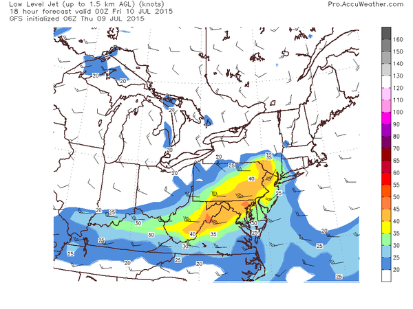 [Forecast map of low-level jet at 8pm this evening; map courtesy AccuWeather, Inc.]
Discussion
The atmosphere is quite juicy this afternoon and numerous thunderstorms are breaking out across western PA, western NY, and West Virginia and some of this activity will spill over into the immediate I-95 corridor region from DC-to-Philly-to-NYC later today and early tonight. As low clouds have eroded somewhat today, the atmosphere has destabilized rapidly and high dew points have contributed to the firing up of very impressive-looking thunderstorms. Some of these storms will likely reach strong-to-severe levels over the next few hours raising the possibility of heavy downpours, damaging wind gusts, hail, and even isolated tornadoes in the I-95 corridor. Of particular concern is the deep wind shear (increasing winds with altitude) in the region near and north of the PA/MD border which tends to promote longer and more intense thunderstorms, damaging wind gusts and even the formation of tornadoes. The wind forecast map for early tonight (above) shows an impressive low-level jet near and to the west of Route I-95 and this will contribute to the instability in the atmosphere.
Closer to the coastline, marine air may reduce the chances for severe weather as it remains a bit cooler compared to inland locations, but heavy rain is still a threat early tonight. The threat for severe weather will diminish late tonight and the next three days should be much quieter with primarily rain-free conditions. The timetable for the potential severe weather in the I-95 corridor has been pushed back a bit into the 5-10pm time period. Stay tuned.