3:05 PM | 115th anniversary of America's Deadliest Natural Disaster - The Galveston Hurricane of 1900
Paul Dorian

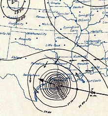
[Surface weather analysis of the Galveston hurricane on September 8, 1900 just before landfall]
Discussion
At the end of the 19th century the city of Galveston, Texas was a booming town with a population of 37,000 residents. The city of Galveston lies on the east end of Galveston Island which runs about thirty miles in length and anywhere from one and a half to three miles in width. Its position on the harbor of Galveston Bay along the Gulf of Mexico made it the center of trade and the biggest city in Texas in the year 1900. A quarter of a century earlier, a nearby town was destroyed by a powerful hurricane and this object lesson was heeded by many Galveston residents and talks of a seawall to protect the city were quite prevalent; however, no seawall was built and sand dunes along the shore were actually cut down to fill low areas in the city, removing what little barrier there was to the Gulf of Mexico.
By late August of 1900 the local residents couldn’t help but to have an uneasy feeling as they knew the heart of the hurricane season had arrived and there was not nearly the weather observation network that we now have with today’s satellites and radar. In fact, ship reports were the only reliable tool for observing hurricanes at sea, but these were of somewhat limited warning value as they had no way of telegraphing weather observations ashore. The first formal observation for a developing new eastern Atlantic Ocean storm occurred on August 27th when a ship recorded an area of “unsettled weather” about 1000 miles east of the Windward Islands. This storm is believed to have begun as a “Cape Verde-type” hurricane – a tropical wave moving off the western coast of Africa. By September 1st, the US Weather Bureau observers were reporting on a “storm of moderate intensity” southeast of Cuba. The storm made landfall on southwest Cuba, but some of the reports that surfaced from Cuba were simply not believed as there was a distrust of Cuban weather forecasters. By September 5th, the system emerged into the Florida Straits as a tropical storm or weak hurricane. By the afternoon of the 7th, large swells from the southeast were observed on the Gulf of Mexico from Galveston Island and clouds at all altitudes began moving in from the northeast – both observations consistent with a hurricane approaching from the east. The Galveston Weather Bureau office raised its double square flags indicating a hurricane warning was in effect. By early afternoon on Saturday, September 8th, the Bureau office was recording hurricane-force winds.
In the early part of the night of September 8th, 1900 - a terrifying night that reshaped the Gulf of Mexico forever - the wind direction shifted to the east, and then to the southeast as the eye began to pass over the island just to the west of the city. The hurricane brought winds that evening estimated to be near 145 mph at landfall making it a Category 4 on today’s rating scale – stronger than Hurricane Katrina of 2005. It also brought a storm surge of over 15 feet that inundated most of Galveston Island and the city of Galveston. By the next morning, skies had cleared and a 20 mph breeze greeted the Galveston survivors, there were 3600 homes destroyed, and it was quite obvious that there was a tremendous loss of life. The storm continued on its trek producing lots of heavy rain and strong winds along the way, first tracking into Oklahoma, then the Great Lakes, and ultimately to near Halifax, Nova Scotia. As far away as New York City there were winds estimated as high as 65 mph - some four days after the devastation occurred in Galveston.

[Track of Galveston hurricane; courtesy Unisys]
The Galveston Hurricane of 1900 is estimated to have killed as many as 12,000 individuals, but the number most often cited in official reports is 8000 – the true number will never be known. More people were killed in this single storm than the total of those killed in all the tropical cyclones that have struck the United States since. Indeed, the Galveston Hurricane of 1900 is the deadliest natural disaster to ever strike the US. By contrast, the second deadliest storm to strike the US, the 1928 Okeechobee hurricane, caused more than 2500 deaths and the deadliest storm of recent times, Hurricane Katrina of 2005, claimed the lives of approximately 1800 people.
Galveston never regained its former status as a major commercial center as development shifted north to Houston, which was enjoying the benefits of an oil boom. A 17-foot seawall was built beginning in 1902 and perhaps an even more dramatic effort to protect the city was its raising. Dredged sand was used to raise the city of Galveston by as much as 17 feet above its previous elevation. In 1915, a storm similar in strength and track to the 1900 hurricane struck Galveston. This storm brought a 12-foot storm surge which tested the new seawall. Although 53 people died on Galveston Island during the storm in 1915, this was a great reduction from the thousands who died in 1900 during the worst natural disaster America has ever faced.

[Survivors carry the dead out of the wreckage]