
1:20 PM | La Nina is coming and global temperatures are responding
Paul Dorian

Sea surface temperatures have changed dramatically since the beginning of this year with a "wavy" pattern of colder-than-normal water (blue) now in the tropical Pacific Ocean; courtesy NOAA
Overview
The collapse of El Nino in the tropical Pacific Ocean has continued throughout the spring season and it should evolve into La Nina conditions by the fall of this year. El Nino is a naturally occurring oceanic cycle that produces warmer-than-normal sea surface temperatures (SSTs) in the equatorial Pacific Ocean whereas La Nina is associated with colder-than-normal SSTs. This now fading El Nino event reached its peak intensity level during December 2015 and rivaled in intensity some of the strongest El Nino’s of the past 50 years including those of 1997-1998 and 1982-1983. El Nino had widespread consequences on weather and climate around the world including a spike in global temperatures and – if history is any guide – its demise and the eventual flip to La Nina will have important consequences as well. In fact, global temperatures have already been dropping noticeably during the past couple of months - typical of post El Nino time periods – and should continue to do so for the foreseeable future as La Nina becomes well established.
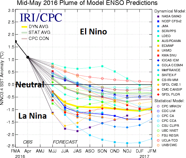
Compilation of computer forecast models which generally support the idea that El Nino will continue to fade away and La Nina conditions will take over by the fall; courtesy NOAA, IRI/Columbia University
Computer model forecasts suggest once La Nina forms it’ll stick around
Numerous independently-made computer forecast models depict a continuation of the demise of El Nino with an eventual flip to La Nina conditions that is likely to then continue into 2017 and perhaps even beyond. The plume of model El Nino Southern Oscillation (ENSO) model forecasts from mid-May (above) indicate a transition to “ENSO-neutral” conditions is likely within the next couple of months and then La Nina conditions are quite likely to take over by the early fall. Sea surface temperatures have indeed changed dramatically in the tropical Pacific Ocean between the early part of this year and today with a “wavy” pattern of colder-than-normal water (bottom panel, blue region) now showing up in the same area that exhibited widespread warmer-than-normal SSTs back in January 2016 (top panel, orange region).

Global temperature anomalies since October 2015 showing a general downward trend since the El Nino induced peak; courtesy Weather Bell Analytics, Dr. Ryan Maue
Global temperatures and El Nino/La Nina
Global temperatures spiked across the world during the El Nino event reaching their peak relative-to-normal during the spring of this year. The global 2-meter temperature anomaly plot (above) shows the trend in global (black), northern hemisphere (blue) and southern hemisphere (green) temperature anomalies since October 2015 as measured by NOAA’s CFSR CFSv2 dataset. Global temperatures have been dropping since the spring season peak and southern hemisphere readings have actually plunged into negative territory relative to the normal of the 1981-2010 time period.

Global temperature anomalies since 2005 with multiple El Nino induced spikes and subsequent drop off in temperatures; courtesy Weather Bell Analytics, Dr. Ryan Maue
In prior El Nino events during the past decade (e.g., 2006-2007, 2009-2010), there were indeed similar El Nino-induced spikes in global temperatures and in each of these cases temperatures dropped off sharply after La Nina conditions became established in the tropical Pacific Ocean. The plot (above) of global temperature anomalies from NOAA's CFSR CFSv2 dataset show clearly the El Nino induced spikes back to 2005 and subsequent temperature drop offs in the post El Nino time periods. Given the notion that once this La Nina becomes established it is likely to have some staying power, it is not unreasonable to assume global temperatures will continue to drop off going into 2017 and perhaps even beyond. As far as the Mid-Atlantic region is concerned, the transition from El Nino to La Nina usually results in hotter and drier summer weather conditions based on analog years and this idea was the foundation of the “2016 Tropical and Summer Outlook”.
Meteorologist Paul Dorian
Vencore, Inc.