3:45 PM | The Arctic invasion has arrived across the Rockies and Northern Plains
Paul Dorian
Discussion
Denver, Colorado enjoyed temperatures in the 70’s on Sunday and now they are in the 20’s with a screaming northerly wind and snowflakes in the air. Temperatures around Denver will likely bottom out tomorrow night near zero in a dramatic change since yesterday. Montana, Wyoming, and the Dakotas have suffered similar plunging temperatures today as the coldest air of the season so far makes serious in roads across the northern US. Accumulating snow is also accompanying the arrival of this Arctic air mass with the heaviest accumulations likely across central Minnesota and northern Wisconsin over the next 12-24 hours. Minneapolis, MN, for example, could end up with a foot of snow by early tomorrow from this first nasty round of winter’s wrath.
As the Arctic front pushes eastward it will lose some of its punch so that temperature departures from normal around here late this week will be only some 10-20 degrees below normal compared to the 30 to 40 degrees in parts of the Rockies and Northern Plains. The Arctic air will arrive around here on Thursday and high temperatures will generally hold in the 40’s as we close out the work week.
Looking ahead, all indications are that this cold pattern will stick around for awhile and reload this weekend and into next week. In fact, there are signs for another widespread Arctic outbreak next week across the eastern 2/3 of the nation that is likely to be colder than this current outbreak. There are also early signs for a storm to pull out of the southern states later next week and, if so, it’ll encounter lots of cold air as it progresses to the north and east. Stay tuned on that potential threat.
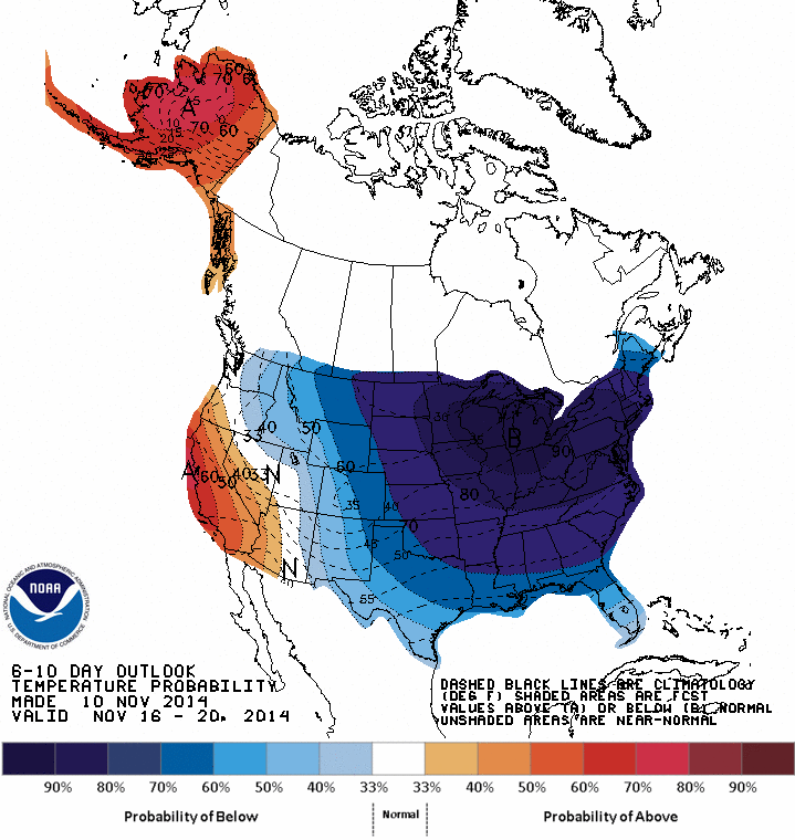
One of the drivers of this cold upper-level pattern is a massive developing ridge in the jet stream over the west coast of North America that is in part being pumped up by the remnants of this weekend’s monster storm over the Bering Strait in the Northern Pacific. Once this ridge fully develops over the next couple of days, it appears it will be in no hurry to leave keeping this cold pattern in place around here into at least Thanksgiving Week. Underneath this massive upper-level ridge will be a powerful surface high pressure system by mid-week over the northern Rockies with central pressures as high as 1050 millibars (31.01 inches). NOAA’s 6-10 day temperature outlook (above) for the period November 16th to 20th (next Sunday through Thursday) depicts the impressive extent of the high probability of colder-than-normal temperatures (blues, purples) extending across much of the nation.