
1:00 PM | Alaska Pavlof Volcano erupts sending ash upwards 20,000 feet
Paul Dorian
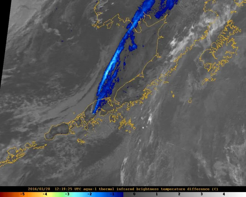
Satellite image showing strong ash signal (blue) extending more than 500 km (300 mi), north-northeast from Pavlof, 4:19 am AKDT (12:19 UTC), Monday, March 28, 2016. (Image courtesy of AVO/USGS)
Alaska's Pavlof Volcano, which is about 600 miles southwest of Anchorage on the Aleutian Islands, erupted at 4:18 p.m. local time on Sunday, March 27th. The eruption sent ash 20,000 feet up in the air and prompted flight warnings according to authorities. Ash was seen generally moving north-to-northeast on infrared satellite imagery both immediately after the eruption (below) and earlier today (above). Seismic activity was also reported after the quake. A volcano alert warning remained in effect early Monday morning and the aviation warning color code remains red, its highest level.

Ash cloud seen on infrared satellite image streaming northward (Sunday, March 27, 2016; 6:45pm local time; image courtesy NOAA)
The volcano is about 4.4 miles in diameter and last erupted in November 2014. In fact, it has had 40 known eruptions and is one of the most consistently active volcanoes in the Aleutian arc. A previous eruption in 2013 sent ash plumes rising 27,000 feet. Other eruptions have generated ash plumes as high as 49,000 feet. The community closest to the volcano is Cold Bay, which is about 37 miles southwest of it.
The USGS is responsible for monitoring volcanic activity in the US, but direct monitoring of Alaska’s volcanoes is carried out by the Alaska Volcano Observatory (AVO), a joint program by the USGS, the University of Alaska Fairbanks Geophysical Institute, and the State of Alaska Division of Geological and Geophysical Surveys. Because volcanic eruptions can last either weeks or months, scientists at AVO are constantly monitoring Pavlof. To detect early signs of unrest in Pavlof’s vicinity, AVO scientists look for satellite data with a strong thermal signal, a sign of high levels of seismic activity in the area. AVO says they knew Pavlof was close to activity at 3:53 pm – about 25 minutes before the eruption – after witnessing high, continuous tremors. And while this isn’t much of a heads up, AVO says the post-eruption protocol is what really matters.
Alaska is home to 52 active volcanoes, 28 of which are monitored with ground-based instruments.