8:30 PM | Hurricane season is now well underway in the Atlantic Basin and there are some amazing on-going streaks
Paul Dorian

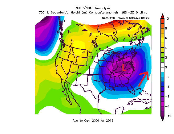
Typical upper-level pattern during the heart of the tropical season in the 2006-2015 time period featured low pressure troughing near the US east coast; courtesy NOAA
Overview
The Atlantic Basin hurricane season is now well underway and there has been somewhat of an active start to the season with one hurricane (Alex) already in the books which formed way back in January and three recent tropical storms (Bonnie, Colin and Danielle). While there is not a significant statistical correlation between early season activity and the tropical season as a whole, there are reasons to believe that this year may end up being more active than recent years which have been relatively quiet for the US mainland. In fact, the Atlantic Basin is in the midst of an unprecedented streak with no major (i.e., categories 3, 4 and 5) hurricane strikes in the US since 2005. In fact, this is the longest streak of that nature since record-keeping began in 1851 and there are some meteorological factors involved. The closest major hurricane drought to that of the present was the smaller 8-year record of 1861-1868. Just as a point of comparison, in 1954 the US was hit by 3 major hurricanes in less than 10 weeks (plot below).

Latest sea surface temperature anomaly chart with fading El Nino and unfolding La Nina (circled region; warmer-than-normal=yellows, oranges, colder-than-normal=blues); courtesy NOAA
El Nino/La Nina
One of the main reasons for the expectation of a more active tropical season in the Atlantic Basin this year has to do with the rapidly fading El Nino (warmer-than-normal water) in the tropical Pacific Ocean and the emergence of La Nina (colder-than-normal water) [SST anomaly chart; warmer-than-normal = yellows/oranges, colder-than-normal = blues]. El Nino tends to be correlated with quieter tropical seasons in the Atlantic Basin as it has been found to have an inhibiting effect on tropical storm formation by increasing vertical wind shear in the Atlantic breeding grounds region. With that particular “beneficial” effect of El Nino now waning, more favorable atmospheric conditions for tropical storm development are likely this summer and fall compared to last season as La Nina tends to suppress those disruptive winds (for more info on this: “2016 Tropical and Mid-Atlantic Summer Outlook”).

"Major" hurricane tracks of the 1950's; map courtesy Joe Bastardi, Weather Bell Analytics
Other atmospheric factors
In addition to the El Nino Southern Oscillation (ENSO) state in the tropical Pacific Ocean, there have been other factors that have played a role in this unprecedented quiet period since 2005 with respect to major hurricane strikes in the US. First, in recent years there has been an abundance of dry air masses pushing westward from the Saharan Desert region of Africa to over the tropical Atlantic Ocean and this has no doubt played a role in inhibiting tropical storm formation. In addition, there have been many tropical systems during the 2006-2015 time period that simply stayed out over the Atlantic Ocean and turned away before ever reaching the Gulf of Mexico or US east coast. One reason for this has been a persistent trough of low pressure at 700 millibars (~10,000 feet) near the US east coast in those years during the heart of the tropical season (August-October). This type of upper-level pressure pattern would tend to produce southwesterly winds just off the US east coast and this would typically keep tropical systems from reaching the US mainland and help turn them to the northeast and out into the open northern Atlantic Ocean.
Additional amazing on-going streaks
Not only has there not been a major hurricane strike on the US mainland since late October 2005 when Wilma struck southwestern Florida, the Atlantic Ocean has had no category 5 hurricanes since 2007 and this is the longest drought of this kind since the period from 1938 (Great New England hurricane) to 1953 (Hurricane Carol) [source Philip Klotzbach, Colorado State University]. In fact, the last category 5 hurricane in the Atlantic Ocean was Felix (2007). In addition to those streaks, one other amazing streak is that the state of Florida has not been hit by a hurricane of any intensity in more than ten years (since Hurricane Wilma). The population in Florida has actually grown in the interim period by more than 2.5 million people. The next longest stretch in Florida without a hurricane strike since record-keeping began in 1851 lasted from 1979 (David) to 1985 (Elena). In 2004 and 2005 alone, seven hurricanes hit Florida (Charley, Frances, Jeanne, and Ivan in 2004; Dennis, Katrina, and Wilma in 2005).
Let's hope these amazing streaks continue during the 2016 tropical season.
Meteorologist Paul Dorian
Vencore, Inc.