9:45 AM | **Heavy rain, strong winds to impact southern California and a dramatic end to the excessive heat...Kay now a tropical storm pushes away from the Baja coastline**
Paul Dorian

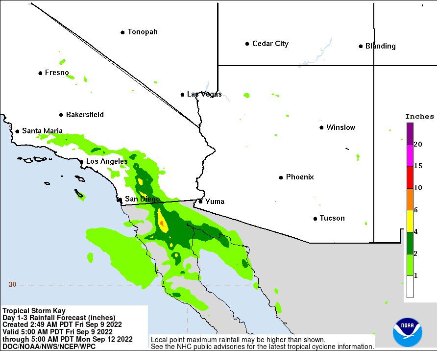
Flash flooding-type rainfall is possible today, tonight and tomorrow in portions of southern California with as much as 4-6 inches. map courtesy NOAA/NWS
Overview
Hurricane Kay has been downgraded to tropical storm status in the overnight hours as it moves roughly parallel to the northwestern coast of Baja California and it will push farther away and continue to weaken over the next 24 hours. However, despite the weakening and the push away from the coast, Tropical Storm Kay will combine with strong high pressure to the north to generate some significant rain and wind across southern California today, tonight and tomorrow. In fact, bands of rain can produce as much as 6 inches in some spots with flash flooding and wind gusts across southern California can reach 60+ mph during this event.

Kay - now a tropical storm - will continue to weaken and push away from the Baja coastline during the next 24 hours. Map courtesy NOAA/NHC
Discussion
Tropical Storm Kay has weakened considerably in the overnight hours now with sustained winds of 50 mph and it will continue to weaken during the next 24 hours as it approaches cooler waters in the chilly “California” current. Despite the weakening, the moisture pushing into southern California is significant and upslope orographic lifting will combine to generate several inches of rain in some spots with flash flooding conditions on the table. The most likely region for the heaviest rainfall will be San Diego and Riverside Counties, but the circulation is so large around Kay that some rain bands can make it farther north into Orange County and the San Bernardino Mountains. Coastal areas in southern California will likely not experience the heavy rainfall expected at inland locations.

Two big players in the weather later today across the western US will include Tropical Storm Kay just off the northwest coast of Baja California and strong high pressure moving over Montana. Map courtesy NOAA, tropicaltidbits.com
In terms of winds, strong easterly winds in the overnight hours gusted as high as 58 mph and the downsloping effect kept overnight temperatures at very warm levels in southern California with San Diego as an example, holding in the mid-to-upper 80’s for overnight lows. Strong wind gusts of 60+ mph are likely from today into early tomorrow s a result of very strong high pressure to the north and the departing tropical system over the eastern Pacific with downed trees and power lines possible.

A dramatic reversal in temperatures is coming to southern California for the weekend following the high heat of recent days. Map courtesy NOAA, tropicaltidbits.com
Winds will decrease from later tomorrow into Sunday and the excessive heat of the several days will change dramatically to colder-than-normal conditions over southern California from this weekend into the early part of next week.
Meteorologist Paul Dorian
Arcfield
arcfieldweather.com
Follow us on Facebook, Twitter, YouTube