11:30 AM | *Major cold wave invades the nation next week as overall weather pattern looks increasingly winter-like*
Paul Dorian
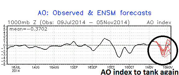 [Arctic Oscillation index: actual (black), forecast (red); courtesy NOAA]
Discussion
A couple of weeks ago, Vencore Weather put out the 2014-2015 Winter Outlook calling for a cold and snowy winter in the Mid-Atlantic region with a quick start including some notable cold and snow in December - well that last part of the winter outlook may just have to be revised slightly as the unfolding weather pattern could actually bring the real start of winter to this month rather than waiting for December.
To begin with, the Arctic Oscillation (AO) index which was highlighted in the Winter Outlook discussion is about to tank once again into deep negative territory which is suggestive of “high-latitude blocking” in the upper atmosphere of the higher latitudes and this usually is followed by Arctic air outbreaks into the northern US. Indeed, blocking in the higher latitudes will force an Arctic air mass to plunge into the mid-section of the country by next Tuesday and that impressive major cold air outbreak will likely reach the Mid-Atlantic region at mid-week. Next week’s early season Arctic air outbreak will be backed up by a monster high pressure system of 1040 millibars or higher and has the potential to produce record-breaking cold in much of the eastern half of the nation.
In addition to the AO, another important factor for our potential winter weather is the snowpack across Eurasia and the entire northern hemisphere as we approach the winter season. Indeed, at the end of October, the snowpack levels were quite impressive in our usual cold air source regions. Statistics gathered by the Rutgers Snow Lab in New Jersey show that the end-of-October snowcover is the 3rd highest in the last 47 years for the northern hemisphere and 2nd highest across Eurasia in that same time period. All of this bodes well for cold and snow in the northeastern US during the upcoming winter as described in detail in the Winter Outlook discussion. The plot below displays the northern hemisphere snowcover as of November 2nd for 2014 (right) and 2007 (left) - notice the significantly higher amounts of snow throughout Eurasia (white area) and even on this side of the north pole at this crucial time of year heading into the winter season.
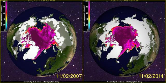 [Northern hemisphere snowcover comparison for 2007 and 2014; data courtesy University of Illinois "cryosphere"]
2014-2015 Winter Outlook: http://vencoreweather.com/2014/10/15/1200-pm-2014-2015-winter-outlook-by-vencore-weather-looks-cold-and-snowy-for-the-mid-atlantic-region/