12:45 PM | ****Spotty snow, sleet next couple hours, but then more widespread mixed precipitation for the mid and late afternoon hours...Snowstorm threat late Wednesday night/Thursday****
Paul Dorian
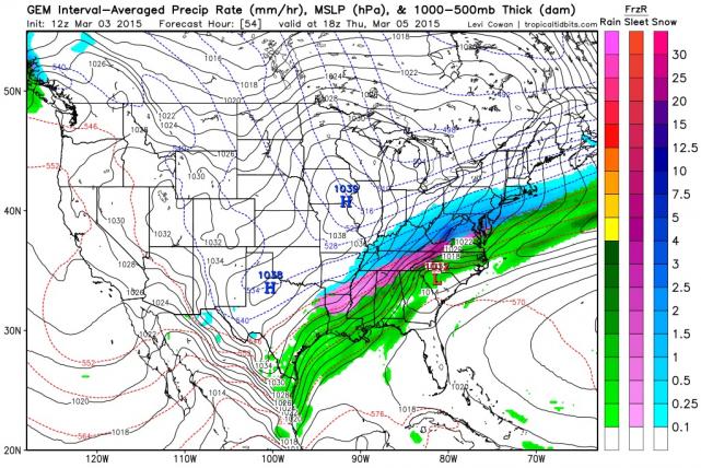 [Tuesday 12Z Canadian forecast map for Thursday mid-day (blue=snow)]
Discussion
Overview The next 48 hours will be quite wild in the I-95 corridor region from DC-to-Philly-to-NYC. First, more snow and ice will develop later this afternoon and continue into the evening. This will very likely create numerous slippery spots for the evening commute with a fresh coating to an inch or two of snow/ice accumulations. Then, milder air will push in overnight, and any wintry mix that falls this evening should change to plain rain by late tonight and Wednesday promises to be a milder day with occasional rain and patchy fog possible. After that, the potential exists for the biggest snowfall of the year from late Wednesday night into Thursday which could very well shut things down in the I-95 corridor on Thursday.
Snow, ice threat for this afternoon and evening Current radar shows spotty snow and sleet developing just to the west of DC and Philly. The entire region from DC-to-Philly-to-NYC should see spotty snow and/or sleet during the early afternoon hours, but then the mixed precipitation becomes more widespread during the mid-to-late afternoon hours. There will likely be numerous slick spots for the evening commute and a coating to an inch or two of snow/ice is quite likely by later this evening. Milder air will cause the wintry mix to transition to plain rain in most locations by late tonight as temperatures slowly rise.
Wednesday – milder with plain rain Wednesday promises to be a milder day with periods of rain. Temperatures could even flirt with the 50 degree mark on Wednesday in southern portions of the I-95 corridor. The more important story; however, will be the approach of another Arctic cold frontal system. This front will pass through the region late Wednesday and this will begin a downward trend in temperatures that could set the stage for a snowstorm in the I-95 corridor from late Wednesday night into Thursday.
Late Wednesday night/Thursday – Snowstorm threat Once the Arctic front reaches the east coast, it will stall out due to the alignment of the upper-level winds which will prevent any significant movement to the southeast. At the same time, copious amounts of moisture will begin heading northeast along the stalled out frontal boundary zone and colder air will be pushing in from the northwest. The result could very well be the biggest snowfall of the year in DC, Philly and NYC with 6-12 inches of accumulation on the table. Very cold weather closes out the work week.
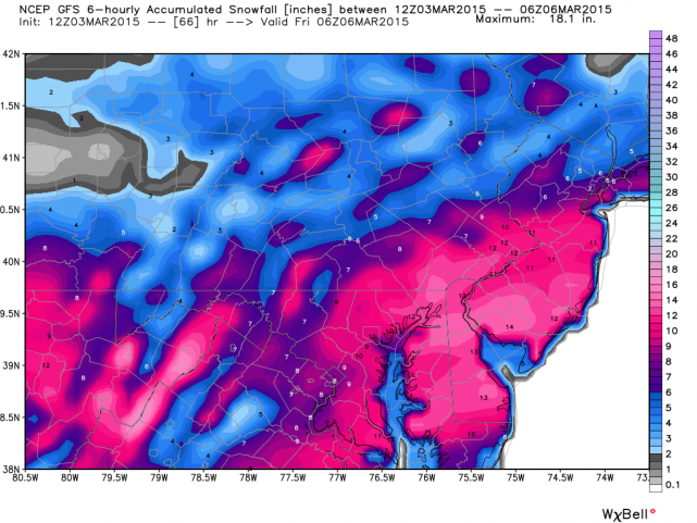 [Tuesday 12Z GFS snowfall forecast map for the late Wednesday night/Thursday storm]