9:00 AM | Another down year in the US for hurricanes and tornadoes
Vencore Weather
Overview
More good news this year for the nation on the extreme weather front as it has been another down year in terms of hurricanes and tornadoes. The Atlantic Basin hurricane season officially ends tomorrow, December 1st, and it is quite likely safe to say that this will be another below-normal year in the US for land falling tropical storm activity. In fact, the US has not been struck by a major hurricane (category 3, 4 or 5) in slightly more than ten years and this is the longest drought of that kind since record-keeping began in 1851. In addition, 2015 is turning out to be another below-normal year for tornadoes across the nation and this too continues a trend that is a decade in the making.
Hurricanes
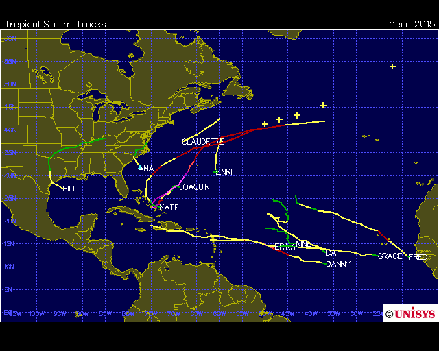
The 2015 hurricane season has generally been a quiet one for the US and below-normal for the Atlantic Basin as a whole. Much of this can be attributed to El Nino in the tropical Pacific Ocean (warmer than normal water) which tends to generate increased wind shear in the tropical Atlantic Ocean which, in turn, inhibits tropical storm formation. As of November 29th, there have been eleven named storms for the year in the Atlantic Basin – Ana, Bill, Claudette, Danny, Erika, Fred, Grace, Henri, Ida, Joaquin and Kate. Four of these storms reached hurricane status and two (Danny and Joaquin) became major hurricanes. There were only two tropical systems (Ana and Bill) which directly impacted the continental US and neither of these reached hurricane status. Joaquin turned out to be the strongest storm of the year (category 4, winds just 2 mph shy of becoming a category 5) and while it did not have a direct hit on the US, it contributed to excessive rainfall and flooding in the Carolinas.
In terms of Accumulated Cyclone Energy, or ACE, this tropical season in the Atlantic Basin is only 58% of normal when using the 1981-2010 time period for comparison (Data source: Dr. Ryan Maue of Weather Bell Analytics; http://models.weatherbell.com/tropical.php). ACE is a commonly-used metric for activity because it is not dependent on exact numbers of named storms or hurricanes, but rather is based on both the intensity and longevity of all tropical storms and hurricanes (so a long-lived tropical storm could contribute as much ACE as a short-lived storm that reached hurricane intensity). On a global basis, ACE is above normal this year thanks in large part to enhanced tropical activity in the Pacific Ocean due to the impact of strong El Nino conditions.

Tropical storm/hurricane tracks for 2015 in the Atlantic Basin; map courtesy Unisys Weather
An interesting stat with respect to US hurricanes has to do with the fact that we are currently in the longest period since records began without a major hurricane strike in the US (i.e., category 3, 4 or 5). The last major hurricane to strike the US was Hurricane Wilma during late October of the record-breaking year of 2005 - let’s hope this historic stretch continues. October 24th marked the 10th anniversary of the last major hurricane hit in the US, the last one being Wilma in the southwestern part of Florida. The closest major hurricane drought to that of the present was the smaller 8-year record of 1861-1868. Also, for the second year in a row, there were no hurricanes in the Gulf of Mexico or Caribbean Sea which is the first time since 1994 that there has been this kind of lack of activity in normally quite active regions. Furthermore, the state of Florida has quite amazingly now gone through their longest stretch ever without a hurricane of any intensity – ten years as of October 24th – with the next longest prior stretch only five seasons (1980-1984) since record-keeping began in 1851. In 2004 and 2005 alone, seven hurricanes hit Florida (Charley, Frances, Jeanne, and Ivan in 2004; Dennis, Katrina, and Wilma in 2005).
By the way, just as another point of comparison, in 1954 the US was hit by 3 major hurricanes in less than 10 weeks.
Tornadoes
Hurricanes are not the only type of extreme weather that are below normal in the US during 2015. The first figure below shows that through November 28th the number of US tornadoes is 1166 based on preliminary reports reported to NOAA’s Storm Prediction Center (Norman, Oklahoma). This is well below the average of 1341 in the 2005-2014 time period. The second figure below indicates that US tornadoes were below the 25th percentile ranking when compared to long-term averages (source: http://www.spc.noaa.gov/wcm/).
In addition to the good news on the number of tornadoes this year, there is also good news in terms of the number of intense tornadoes. As of today, there have only been 16 tornadoes nationwide classified at the level of "EF3+" which is the lowest total since 1950 except for the year 1987. Furthermore, there has only been 1 tornado this year classified at the "EF4+" level and this matches 2005 for the lowest total in any year since 1950. The best news of all is that if current trends continue through December, this could turn out to be the least-deadliest year ever in the US for tornado-related deaths.
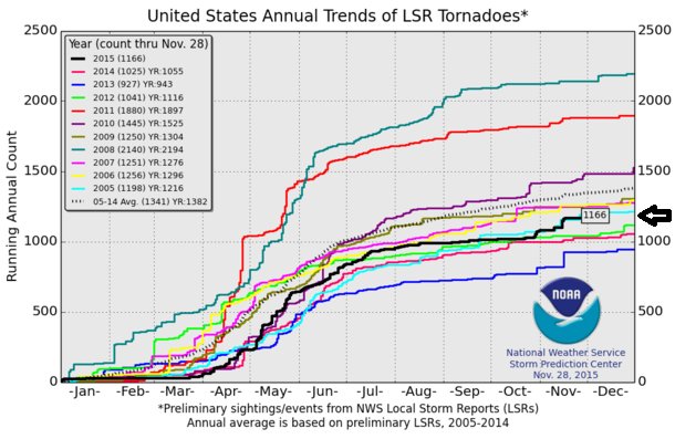
Preliminary tornado reports for 2015 versus other years in the last decade; courtesy NOAA Storm Prediction Center
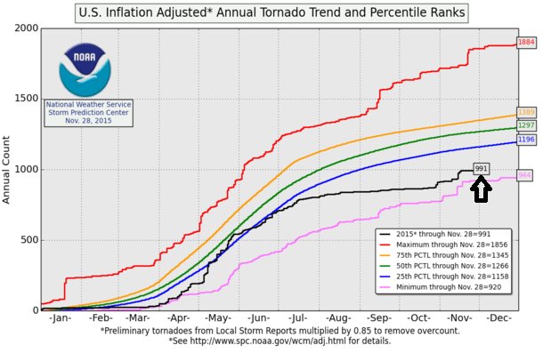
Preliminary tornado reports for 2015 as a percentile ranking; courtesy NOAA Storm Prediction Center
One final word of caution
There is a word of caution, however, when it comes to the potential for hurricane strikes in the US during the next year or two. This year’s strong El Nino event in the tropical Pacific Ocean is quite likely to weaken significantly during 2016; consequently, the “beneficial” effect of El Nino-induced increased wind shear in the Atlantic Basin is likely to diminish as well. This is quite likely to result in an uptick in tropical activity in the Atlantic Basin during 2016 – perhaps even significantly in terms of overall ACE. In addition, there is a real possibility that a full-blown La Nina (colder-than-normal water) develops in the tropical Pacific Ocean later next year and continues into the year 2017 and this could extend next year’s potential uptick in activity right into 2017.
Paul Dorian
Vencore, Inc.