
12:10 PM | **Accumulating snow later tonight into early Wednesday...very cold late week...brutally cold this weekend...another snow threat early next week**
Paul Dorian
Overview
Our very active weather pattern continues for the foreseeable future and it looks like it will bring accumulating snow to the Mid-Atlantic region from later tonight into early Wednesday. In addition, it'll turn very cold for the Thursday/Friday time period and then absolutely frigid this weekend with zero degree readings on the table and perhaps the coldest Valentine's Day (Sunday) in a long, long time. As this tremendous Arctic blast arrives on Friday night, there could very well be some snow shower and snow squall activity in the I-95 corridor. On top of all that, there is the chance for more snow early next week – something about President’s Day that attracts snowstorms.

12Z GFS total precipitation amounts between now and early Wednesday. Circled region is roughly the potential zone for heaviest snowfall; map courtesy NOAA
Today
Powerful low pressure today is moving slowly to the northeast just off the coast and, for the most part, it won’t have an impact on the corridor from DC to New York City. Most of its snowfall today has been from New York City and points east and north in places like Long Island and southern New England - no precipitation has reached the DC or Philly metro regions from this ocean storm.
Monday night into Wednesday
Another low pressure system will trek across the Great Lakes and Ohio Valley later tonight and Tuesday and it will transfer its energy to a coastal storm east of the Delmarva Peninsula that will produce an extended period of snow in the region with accumulations. This type of system has the chance to produce accumulations on the order of a couple of inches-to-several inches for parts of the Mid-Atlantic region, but confidence is not too high yet as to exactly where that total snowfall accumulation pattern will set up later tonight and Tuesday. Generally, in these types of scenarios, there are small-scale or “mesoscale” narrow bands of heavier snow that setup to the northwest of the surface low and this is likely to be across southern Pennsylvania and northern Maryland. The 12Z GFS total precipitation amounts by early Wednesday show higher amounts in this zone (as indicated by circled region). Heavier snowfall amounts can be expected underneath these narrow bands with lesser amounts in other areas. A small shift to the north or south in this expected zone of heaver snow banding would result in a corresponding shift in overall snowfall amounts, but right now the zone of heaviest snowfall is looking like it'll occur from DC-to-Philly with less in New York City

12Z GFS snowfall map next 60 hours; courtesy instantweathermaps.com, NOAA
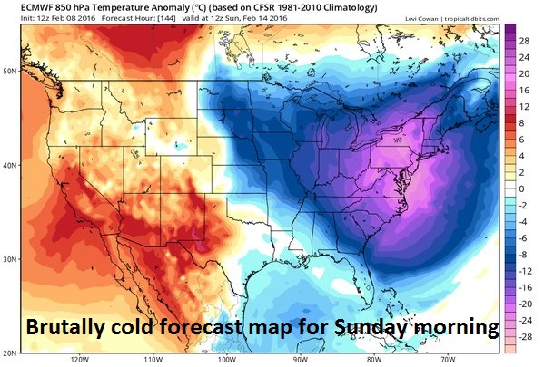
12Z Euro model forecast map for lower atmosphere temperature anomalies on Sunday morning; courtesy tropicaltidbits.com
Preliminary snowfall estimates
The preliminary snowfall estimates are listed below for the period from later tonight into early Wednesday. This will be a wet, slushy type of snow that should initially build up on non-paved surfaces.
Philly: 3-7 inches with the higher amounts in that range more likely to the southwest of the city (e.g., Chester, Delaware Counties); isolated higher amounts possible
DC: 2-6 inches with the higher amounts in that range more likely to the northeast of the District (e.g., northern Montgomery and northern Prince Georges Counties); isolated higher amounts possible
NYC: a general 2-4 inches
Meteorologist Paul Dorian
Vencore, Inc.