
2:10 PM | *La Nina is coming and is likely to impact the upcoming winter, next summer's tropical season, and global temperatures*
Paul Dorian

Sea surface temperatures have dropped in the tropical Pacific Ocean during the last five months; data courtesy NOAA
Overview
Earlier this year, there were signs that a weak El Nino in the tropical Pacific Ocean could continue through the fall and even into the upcoming winter season, but there is now substantial agreement amongst numerous computer forecast models that La Nina conditions are likely to become established over the next couple of months and current observations back this notion. La Nina is a naturally occurring oceanic cycle that produces colder-than-normal sea surface temperatures (SSTs) in the equatorial Pacific Ocean whereas El Nino is associated with warmer-than-normal SSTs. The formation of La Nina in the tropical Pacific Ocean will likely have important ramifications around the world including significant impacts on the upcoming winter season, next summer’s tropical season, and global temperatures.
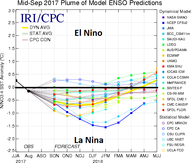
Compilation of statistical and dynamical computer forecast models of ENSO in coming months. Most of these models predict La Nina conditions will form over the next couple of months in the tropical Pacific Ocean.; courtesy IRI/CPC
Computer model forecasts support the formation of La Nina
Numerous independently-made computer forecast models depict a change from the current near-neutral conditions in the tropical Pacific Ocean to La Nina conditions by the winter of 2017-2018. The plume of model El Nino Southern Oscillation (ENSO) model forecasts from mid-September indicate a transition to La Nina conditions are quite likely to take hold by later this fall. Indeed, some models are predicting a fairly strong La Nina by the middle of the upcoming winter season with sea surface temperatures as much as 1.5°C below-normal in the "Nino 3.4" region (central tropical Pacific).
Sea surface temperatures have indeed changed dramatically in the tropical Pacific Ocean between the spring and today with a “wavy” pattern of colder-than-normal water (bottom panel, blue region) now showing up in the same area that exhibited widespread warmer-than-normal SSTs back in April 2017 (top panel, yellow/orange region).

Temperature and precipitation composites are shown for "January/February/March" during La Nina winters; data courtesy NOAA
Impact on upcoming winter season
While there are numerous factors to consider when formulating an outlook for the winter season including North Atlantic sea surface conditions, the sea surface temperatures in the tropical Pacific Ocean can certainly be quite important. Strong El Nino winters, for example, can produce warmer-than-normal conditions in much of the US and can also contribute to occasional blockbuster east coast snowstorms.
Typically, La Nina winters tend to result in colder-than-normal temperatures across the northwest/north central US and warmer-than-normal conditions in the southeast US (left panel) with the Mid-Atlantic region somewhere in the middle (i.e., closer-to-normal). In addition, precipitation tends to run higher-than-normal across the Midwest and Northeast US during La Nina winters (right panel) and this could lead to more snowfall than normal in those specific parts of the country. [Note- the “2017-2018 Vencore Winter Outlook” will come out later in the fall…one factor that is important to me and yet-to-be determined is how the snowpack builds up during the month of October across important cold air sources such as Siberia].
Impact on next summer’s Atlantic Basin tropical season
One of the benefits of an El Nino event is that this type of sea surface temperature pattern in the tropical Pacific Ocean (i.e., warmer-than-normal) tends to result in less tropical activity compared-to-normal for the Atlantic Basin. This is often the result of an El Nino since they tend to generate higher-than-normal wind shear in the breeding grounds region of the tropical Atlantic Ocean which tends to inhibit the formation or intensification of tropical systems. Therefore, with La Nina likely to become well-established in coming months and little chance of an El Nino, next summer’s Atlantic Basin tropical season is liable to be another active time period – just as it was in this year’s still on-going busy season.
Impact on global temperatures
Global temperatures spiked across the world during the last strong El Nino event which reached a peak during the latter part of 2015 and early part of 2016 and they have trended slightly lower this year from that high point. According to Weather Bell Analytics, NOAA’s CFSv2 global temperature anomalies spiked in 2016 to +0.457°C above the 1981-2010 average and those anomalies - while still above normal - have dropped slightly this year to +0.382°C (through October 2nd). If history is any guide, once La Nina becomes well-established in the tropical Pacific Ocean, global temperatures should drop noticeably relative-to-normal.
Meteorologist Paul Dorian
Vencore, Inc.
vencoreweather.com