
10:15 AM | ***Relentless and punishing Arctic cold for much of the nation through next week***
Paul Dorian

2-meter temperature anomalies averaged over 5-day period (days 1-5); courtesy NOAA/EMC, tropicaltidbits.com
Overview
Arctic cold will be relentless and punishing for much of the nation for several days to come and many areas will be experience some of the coldest weather in decades to begin a new year. In fact, the three week stretch from around December 20th to January 10th could be one of the coldest stretches we’ve had across much of the nation in a long, long time. A "clipper" system will drop southeastward and into the Mid-Atlantic region by Saturday – likely with some accumulating snow on the order of a dusting to an inch or two – and it will usher in brutally cold Arctic air for the Sunday, Monday, and Tuesday time period. Indeed, it will be frigid on New Year’s Eve at Times Square in New York City, for all activities on the National Mall in Washington, DC and it will be brutal for the Mummer’s Parade in Philly on Monday. Looking ahead, there may be a snow threat coming to the east coast during the middle or latter part of next week, but it is too early to say if this potential system develops close to the coast or too far off the coast.

2-meter temperature anomalies averaged over 5-day period (days 6-10); courtesy NOAA/EMC, tropicaltidbits.com
Details on the Arctic cold
Sprawling Arctic high pressure is controlling the weather scene across much of the eastern two-thirds of the nation and will continue to do so at least right through next week. This cold wave will continue to extend all the way from the Rockies to the east coast and all the way south to the Gulf region from southern Texas to southern Florida over the next several days. Many areas will experience the coldest “end-of-year, beginning-of-the new year” weather since the winter season of 2000-2001 and the cold wave is likely to continue into at least the second week of January.
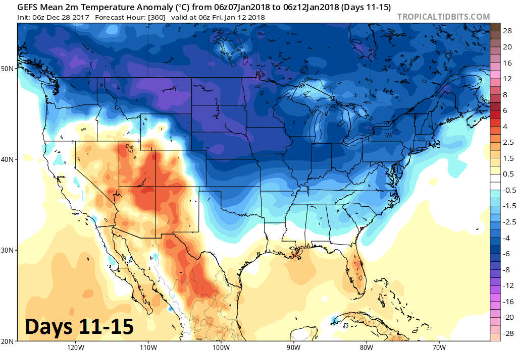
2-meter temperature anomalies averaged over 5-day period (days 11-15); courtesy NOAA/EMC, tropicaltidbits.com
Some of the most impressive temperatures so far in this cold wave have taken place in the Upper Midwest and Northeast US. For example, Chicago’s high temperature on Tuesday of 5 degrees tied the record for the coldest maximum temperature on Dec. 26; Detroit tied the daily record low for Dec. 27 of minus-4 Wednesday, previously set in 1925; International Falls, Minn. plummeted to minus-36 Wednesday, breaking the previous record of minus-32 for the date; Flint, Mich. set an all-time Dec. record low Thursday falling to minus-17 and
Watertown, N.Y. shattered Thursday’s previous record low of minus-23, falling to minus-32. (Source Washington Post/CWG).
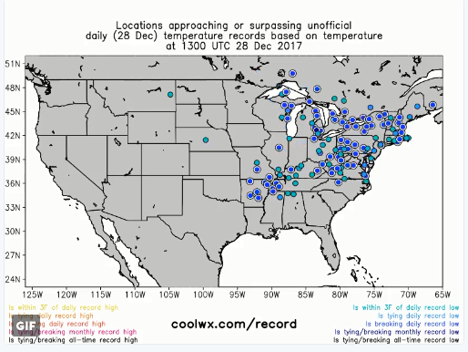
Cities with record or near record lows this morning; map courtesy coolwx.com
Snow threats
As far as snow is concerned, the deep penetration of the Arctic cold has so far tended to prevent any serious snow threats to reach the Mid-Atlantic region or Northeast US from the southern states. A "clipper" system is likely to produce some accumulating snow on Saturday (dusting to an inch or two) despite the fact that it will have limited available moisture. With cold air in place, the "snow-to-liquid" ratios will be quite high (perhaps 20:1) for this system allowing for the possibility of some snow accumulations despite little in the way of "precipitable water" content in the atmosphere. During the middle or latter part of next week, there may be a chance for more snow as a storm tries to ride up along the east coast, but it is too early to tell if this potential system forms near the coast or too far off of the coast.
Meteorologist Paul Dorian
Vencore, Inc.
vencoreweather.com
Detailed video discussion on the Arctic cold: