
2:30 PM | *Growing threat of a major end-of-week rain event*
Paul Dorian
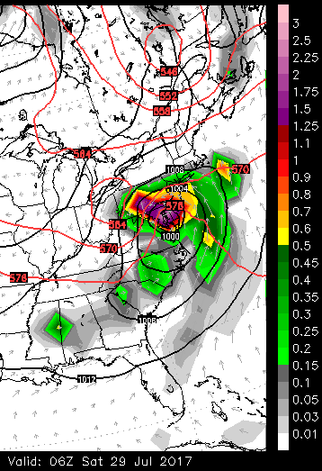
Euro model forecast of 6-hour rainfall amounts ending at 2am on Saturday morning (legend on right side). Low pressure centered over the Delmarva Peninsula at this time in a pattern quite similar to a wintertime nor'easter. Map courtesy WSI, Inc.
Overview
There is growing likelihood for yet another major rain event in the DC-to-Philly-to-NYC corridor and this could easily result in flash flood watches and warnings for much of the region at the end of the work week. High pressure will push off the Northeast US coastline on Thursday and a warm front will approach the area later in the day from the southwest. This front will stall out over the region on Friday and allow low pressure to track right along its boundary zone. This low pressure system will have tremendous support in the upper atmosphere and it could ultimately turn out to be an uncommon late July nor’easter.
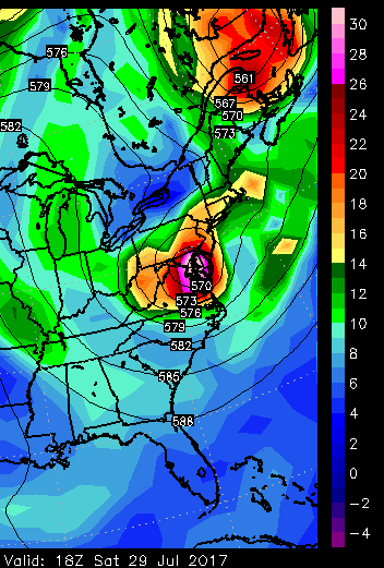
Euro model forecast of 500 mb vorticity at 2pm on Saturday afternoon. A vigorous wave of energy in the upper atmosphere will help to generate a nor'easter-type system along the Mid-Atlantic coastline at week's end. Map courtesy WSI, Inc.
While there can be a few showers and thunderstorms tomorrow and tomorrow night, the main event around here looks like it will come later Friday and especially Friday night with numerous showers likely and possible strong thunderstorms mixed into the picture. Some of the rain is quite likely to be heavy at times during this upcoming event and - given the already-saturated grounds in many areas - flash flooding may become a real concern. The rain could even linger into the first part of the weekend; especially, near coastal sections. High pressure will eventually win out later in the weekend promoting clearing skies around here and temperatures should remain quite comfortable on both Saturday and Sunday. The latest Euro model forecast goes all out with the prediction of torrential rainfall in the DC, Philly, NYC metro regions centered in the Friday night time frame.
Meteorologist Paul Dorian
Vencore, Inc.
vencoreweather.com