
1:40 PM | *”Beast from the East”…upper-level pattern changes to bring extreme cold from Siberia westward into Europe…these same changes to bring colder pattern back to the US and powerful ocean storm*
Paul Dorian
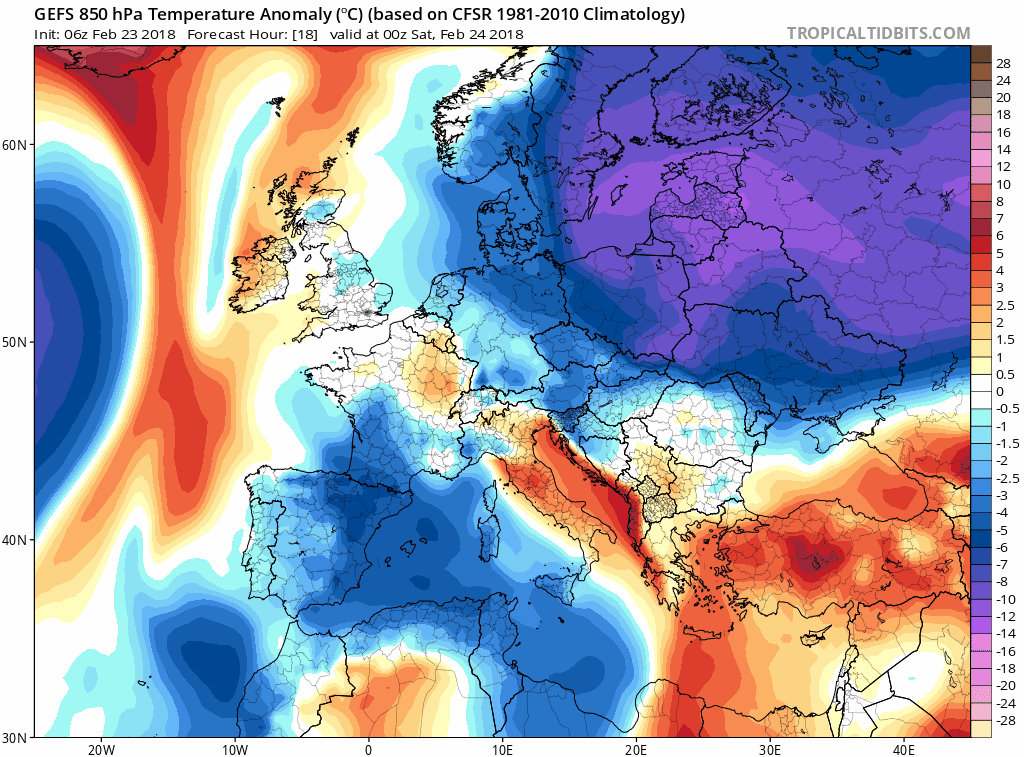
06Z GEFS 850 mb temperature anomaly loop over the next five days (Friday night 2/23 - Wednesday night 2/28) in 6-hour increments with extreme cold from Siberia spreading westward into Europe; maps courtesy NOAA/EMC, tropicaltidbits.com
Overview
There has been a major stratospheric warming event over the past couple of weeks with a displacement of the polar vortex to lower latitudes and over the next several days a significant high-latitude blocking event will unfold leading to way above normal heights over places like Greenland and northeastern Canada. These large-scale atmospheric events are having an impact on weather patterns all across the Northern Hemisphere. They will be contributing factors to the extreme cold that is about to invade Europe from the east (Siberia) and to a cold pattern that looks like it will develop across much of the US during March which may feature a nor'easter during the transition period late next week.

12Z GFS "air flow trajectory" forecast map from now to Friday, March 2nd showing westward movement across the Atlantic Ocean from northern Europe to Canada; map courtesy NOAA/EMC
Discussion
It is being called the “Beast from the East”. Every once in awhile, the overall weather pattern allows for Siberian cold air to trek westward into Europe during the winter season and this is exactly what will happen over the next few days. Extreme cold will spread westward from Siberia into Europe this weekend and there will no doubt be “news-making” cold in Europe well into next week. Significant snow will also take place over the next week from Scandinavia in the north to Italy in the south including in Rome where it is pretty rare. This cold air will continue to spread westward later next week and some air trajectory forecast models (e.g., GFS) actually show air that originates to the east of Greenland will end up taking a westward path in coming days crossing the Atlantic Ocean and reaching places like Nova Scotia, Canada by the end of the next week.

30-day loop of 10-mb (stratospheric) temperatures showing extreme warming over the Arctic as a result of a major stratospheric warming event (24-hour increments); maps courtesy NOAA
In addition to the major stratospheric warming event that unfolded during the past few weeks and warmed up the Arctic significantly, strong high-latitude blocking is about to form over Greenland and northeastern Canada. When such a pattern forms this time of year, cold air masses not only can penetrate into the US and Europe from northern latitudes, they can stick around for lengthy periods of time.

Two indices known as the North Atlantic Oscillation (top) and Arctic Oscillation (bottom) are forecasted (in red) to simultaneously drop sharply into negative territory in coming days which often signals strong high-latitude blocking (arrows show current position); maps courtesy NOAA
Two indices that are tracked by meteorologists that provide some insight into the temperature and pressure patterns of the northern latitudes include the Arctic Oscillation (AO) and North Atlantic Oscillation (NAO). When these indices simultaneously drop sharply into negative territory, a red flag is set off that suggests strong high-latitude blocking may soon develop. Indeed, both of these indices are about to plunge sharply into negative territory.

06Z GEFS 850 mb temperature anomaly loop across the US over a 7-day period from Thursday, March 1st to Thursday, March 8th (6-hour increments) with generally colder-than-normal conditions; maps courtesy NOAA/EMC, tropicaltidbits.com
Next week is likely to remain on the mild side across much of the US, but as March gets underway and the strong high-latitude blocking pattern sets up, a significant change in the overall pattern will develop. Temperatures are likely to transition from warmer-than-normal to colder-than-normal for much of the nation and this change to cold should stick around for awhile thanks to the blocking setup in the upper atmosphere over the northern latitudes. In addition, this transition period is likely to result in a powerful storm near the Mid-Atlantic coastline at the end of next week which could generate heavy rain initially, but then as colder air wraps into the system, accumulating snow may become a serious threat for much of the area.

Strong high-latitude blocking pattern sets up by next Friday, March 2nd (boxed region) with abnormally high heights predicted by the 12Z GEFS over Greenland and northeastern Canada; map courtesy NOAA/EMC, tropicaltidbits.com
Stay tuned...March is looking quite interesting.
Meteorologist Paul Dorian
Vencore, Inc.
vencoreweather.com
Morning video discussion on the short-term rain threats for the Mid-Atlantic region and the longer-term significant pattern change that brings colder weather back to the US in March and the potential for snow: