11:10 AM | *An unfolding major stratospheric warming event is similar to January 1985 and that one preceded a period of extreme cold in the central and eastern US*
Paul Dorian

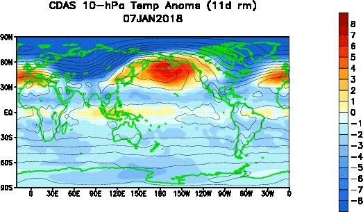
Day-to-day temperature anomalies in the stratosphere (10 millibars) over the past 30-days with substantial warming developing in recent days across the northern latitudes; courtesy NOAA
Overview
One of the ways to monitor the potential for wintertime Arctic air outbreaks in the central and eastern U.S. is to follow what is happening in the stratosphere over the Northern Hemisphere. Sudden Stratospheric Warmings (SSWs) are large, rapid temperature rises in the winter polar stratosphere, occurring primarily in the Northern Hemisphere, and these events have been found to set off a chain of events in the atmosphere that ultimately can lead to Arctic air outbreaks for the central and eastern US that drop southward from northern Canada. Indeed, there is a significant stratospheric warming event now unfolding that will soon result in a dominant polar vortex center over North America - somewhat similar to a major SSW event that took place in January 1985. In that particular year, the major SSW event was soon followed by a period of extreme cold in the central and eastern US.

A jump in stratospheric (10 millibars) temperatures in recent days across the northern latitudes; courtesy NOAA
Details
Sudden stratospheric warmings (SSWs) are among the most impressive dynamical events in the physical climate system. During the winter months in the polar stratosphere, temperatures are typically lower than minus 70° Celsius. The cold temperatures are combined with strong westerly winds that form the southern boundary of the stratospheric polar vortex which plays a major role in determining how much Arctic air spills southward toward the mid-latitudes. This dominant structure is sometimes disrupted in some winters or even reversed. Under these circumstances, the temperatures in the lower stratosphere can rise by more than 50°C in just a few days. This sets off a reversal in the west-to-east winds and the collapse of the polar vortex.
In response to the stratospheric warming (and associated layer expansion) at the high latitudes, the troposphere in turn cools down dramatically (with layer contraction) at the high latitudes. This tropospheric cold air can then be transported from the high latitudes to the middle latitudes given the right overall weather pattern (e.g., "high-latitude blocking"). The tropospheric response to the SSWs closely resembles the negative phase of the North Atlantic Oscillation (NAO), involving an equatorward shift of the North Atlantic storm track; extreme cold air outbreaks in parts of North America, northern Eurasia and Siberia; and strong warming of Greenland, eastern Canada, and southern Eurasia (Thompson et al., 2002). The entire process from the initial warming of the stratospheric at high latitudes to the cooling in the troposphere at middle latitudes can take weeks to unfold.
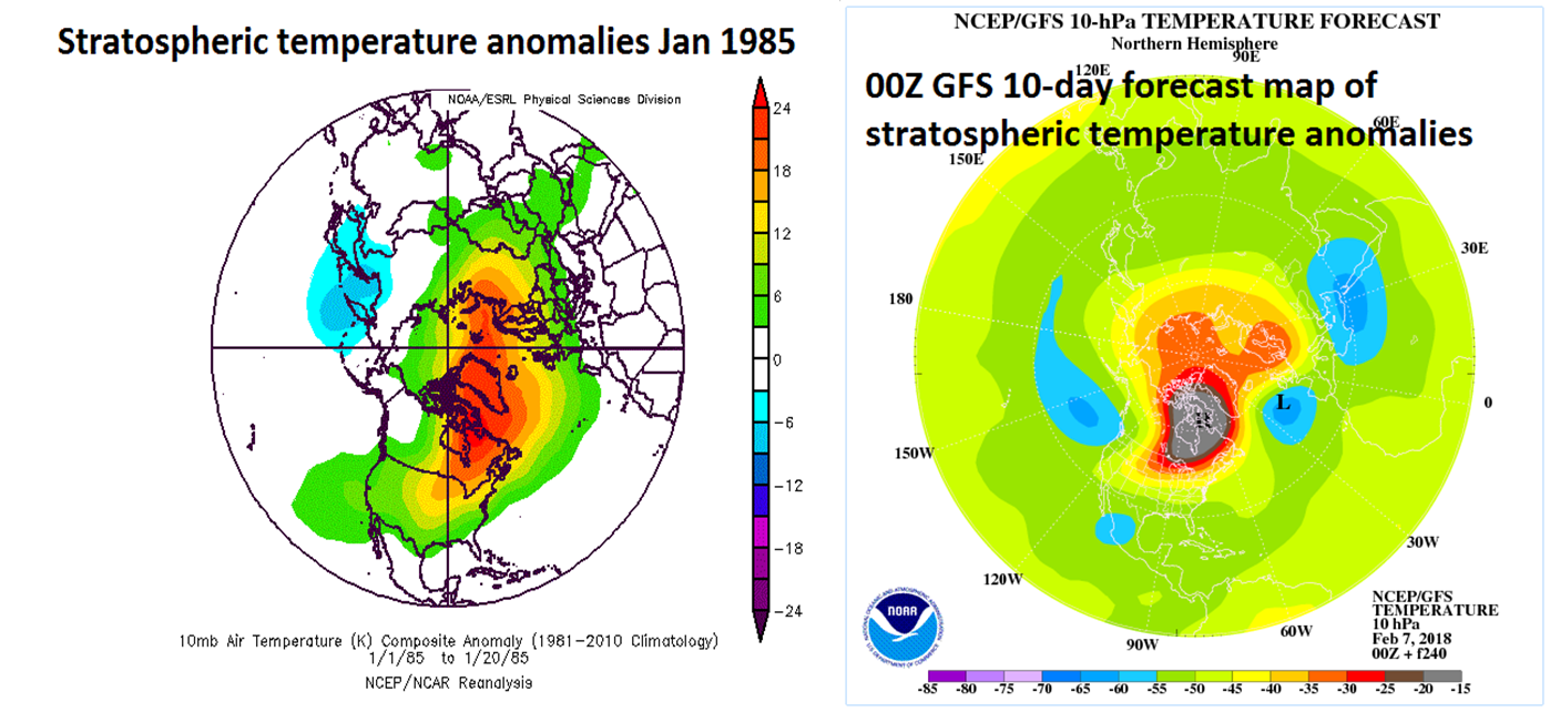
Stratospheric temperature anomalies during January 1985 (left) and the 10-day forecast map for February 17th (right) with similar patterns of much above-normal temperatures on this side of the North Pole. These maps have a "top-down" view of the Northern Hemisphere with the North Pole located right in the center and the US is positioned in the lower-central portion of each map. maps courtesy NOAA
Some stratospheric warming events in recent history have, in fact, been followed by widespread very cold air outbreaks across the central and eastern US - usually some two to three weeks after the initial upper atmosphere warming. For example, a major SSW event began in December 1984 and continued into early January of 1985 and this was followed by a period of extreme cold in the central and eastern US during the latter half of January 1985. In fact, it was so cold for Ronald Reagan’s second inauguration on January 20th, 1985 that all outdoor activities for that day were moved to the inside to protect the public.

Surface temperature anomaly pattern in the US during the latter part of January 1985 following the major stratospheric warming event that is quite similar to the current one; map courtesy NOAA
It is still too early to say exactly where this unfolding stratospheric warming event may result in some extreme cold, but if past history is any guide, it could be in the central and eastern US late this month and/or early in March. In order to determine the exact pathway for potential cold air outbreaks as a result of this SSW event, we'll monitor the prospects in coming days for "high-latitude blocking" using such indices as the Arctic Oscillation and North Atlantic Oscillation. When these indices go "negative" for extended periods of time, the chances of "high-latitude blocking" tends to increase this time of year. A detailed video discussion on the phenomenon of “Stratospheric Warming” can be found on our "Meteorology 101" page with more information on the 1985 event as well as details on some other recent SSW events.
Meteorologist Paul Dorian
Vencore, Inc.
Video discussion on the unfolding major SSW event and MJO progression into "colder" phases: