12:45 PM | ***Monitoring prospects for a powerhouse storm system that can impact the Gulf of Mexico region this weekend and the east coast early next week***
Paul Dorian

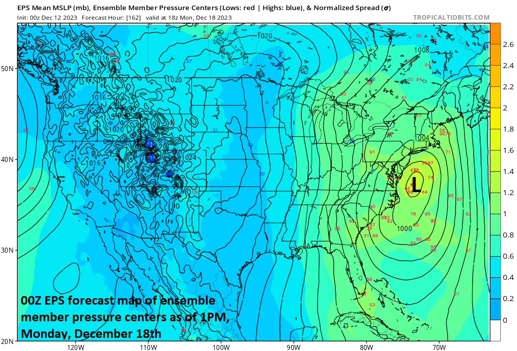
00Z ensemble run of the Euro features low pressure off the Mid-Atlantic coastline early next week. Map courtesy ECMWF, tropicaltidbits.com
Overview
Low pressure will slide across the southwestern states over the next couple of days and likely produce some significant snowfall in the higher elevations of southern Colorado and northern New Mexico. By the weekend, this system will move south and east into the Gulf of Mexico region and begin to intensify. Signs are increasing that at this point the storm will take a turn to the north and east, produce tropical storm-like conditions across Florida including heavy rainfall and strong winds and then likely ride right up near the eastern seaboard with heavy rain and strong winds on the table. Cold air will be lacking in the northeastern states - at least initially – when the storm is likely to hit so rain will be the dominate precipitation type at the start. However, a powerful storm system like this sitting near the Mid-Atlantic/Northeast US coastline can certainly draw in enough cold air in this kind of setup for a changeover to snow in higher elevation, inland locations from upstate New York to northern New England.
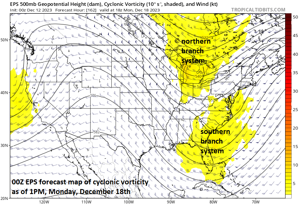
A northern branch upper-level disturbance may “phase” together early next week with a southern branch system to generate a powerhouse surface low pressure system near the US east coast. Map courtesy ECMWF, tropicaltidbits.com
Details
A strong storm system impacted the eastern half of the nation this past weekend and earlier this week with severe weather, rain, snow and wind and signs are increasing for another powerhouse storm system that can have wide-ranging impacts from later this week into the early part of next week. Low pressure will push eastward across the southwestern states during the next couple of days and likely produce several inches of snow in the higher elevation locations of Colorado and New Mexico. After that, the storm will slide across the south-central states and head into the Gulf of Mexico region where vast moisture will be available for the taking. An upper-level low will spin south and east to the Gulf of Mexico region and likely deepen during the upcoming weekend.
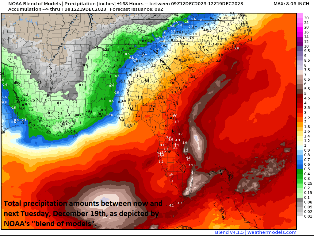
Heavy rainfall amounts from this potential storm system are on the table in the southeastern states by the end of the weekend and then in the Mid-Atlantic/NE US early next week. Map courtesy NOAA, weathermodels.com
By the second half of the weekend, this Gulf storm will begin a push to the north and east and likely result in a heavy rainfall and strong winds for Florida and other sections of the SE US as well. In the upper atmosphere, the low over the eastern Gulf will continue to deepen as it turns to the north and east and a northern stream system will begin to play an increasing role in the overall pattern. The northern system may very well begin to phase with the southern disturbance creating significant intensification of surface low pressure over the southeastern states by late Sunday. If indeed these two features phase together then the pressure gradient field will tighten dramatically between the intensifying low and departing high pressure well to the northeast - potentially resulting in damaging winds across the eastern states. Heavy rain and strong winds are likely to spread northward into the Mid-Atlantic/Northeast US from later Sunday into Monday and additional weather threats could include beach erosion and flooding along coastal sections.
With the lack of cold air at the onset, the likely dominate precipitation type throughout the Mid-Atlantic/Northeast US would be rain. However, there is always the chance that an intense storm system sitting near the Mid-Atlantic/Northeast US coastline can draw in enough cold air from Canada to cause a changeover to snow. This is especially possible across the inland, higher elevation locations of upstate New York and New England and would potentially take place in the late Monday/Tuesday time frame.
Stay tuned…a few days to go before this next significant storm event.
Meteorologist Paul Dorian
Arcfield
arcfieldweather.com
Follow us on Facebook, Twitter, YouTube
Video discussion: