
*****Powerful storm system to impact the Gulf/eastern states Sunday into Monday…torrential rain, strong and potentially damaging wind gusts…cold air on back end*****
Paul Dorian

A strong low-level jet will increase chances for damaging wind gusts during this upcoming event; especially, along coastal sections all along the eastern seaboard. Map courtesy NOAA, tropicaltidbits.com
Overview
Low pressure will slide into the central Gulf of Mexico region by the early part of the weekend and an intensification process will begin there that will soon result in a powerhouse storm system. The intensifying storm system will impact the Florida Peninsula and other parts of the Southeast US on Saturday night and Sunday and then it pushes northward producing rain and wind throughout the eastern states from Sunday into Monday. The rain will be heavy all along the path of the storm and winds are very likely to reach damaging levels; especially, along coastal sections where 60+ mph gusts are possible...power outages are on the table up and down the coast. There will be no cold air around initially in the Mid-Atlantic/Northeast US when the storm hits; however, cold air will pour in from the northwest on Monday night and Tuesday raising the chance for a transition to some accumulating snow on the back end; especially, in “lake-effect” locations just downstream of Lakes Erie and Huron.

Rainfall amounts will likely be high during this upcoming weather event all the way from the Gulf region to New England. Map courtesy ECMWF, Weather Bell Analytics
Details
A strong storm system impacted the eastern third of the nation last weekend with severe weather, rain, snow and wind and an even stronger one is on the way. Low pressure will drop south and east over the next couple of days reaching the central Gulf of Mexico by early Saturday where vast moisture will be available for the taking. Once there, an intensification process will begin that will turn this system into a powerhouse that will have an impact all the way from Florida to Maine. The intensification will begin this weekend when a northern branch disturbance phases together with a southern branch system resulting in a deepening upper-level trough of low pressure that will support strengthening low pressure at the surface.

Strong and potentially damaging winds will take place during this upcoming weather event in the eastern US with coastal sections especially vulnerable to high winds…power outages are on the table. Map courtesy ECMWF, Weather Bell Analytics
The first big impact this weekend from this unfolding storm system will be across the Florida Peninsula and other sections of the Southeast US (e.g., Alabama, Georgia) from Saturday night into Sunday with tropical storm-like rainfall and wind gusts and severe thunderstorms potentially containing isolated tornadoes. This powerful storm system will then ride northward near or along the east coast and it’ll spread rain and wind into the Mid-Atlantic/Northeast US from later Sunday into early Monday. The rain can become very heavy at times and with grounds already well saturated from last weekend’s storm and another 1.5-3 inches possible, flash flooding is likely to become a widespread concern. The wind gusts at the ground level will potentially reach damaging levels and power outages are on the table; especially vulnerable are coastal sections where 60+ mph winds are possible…all aided by a powerful low-level (850 millibars or ~ 5000 feet) jet streak. The general wind flow for and extended period of time will be from an east or southeast direction (i.e., onshore) from later Sunday into Monday raising the chance for beach erosion and coastal flooding from the Carolinas to New England.
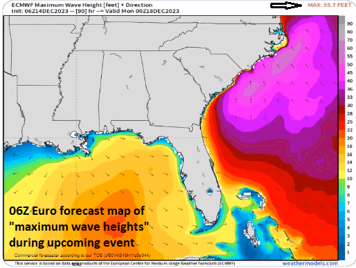
06Z Euro forecast map of “maximum wave heights” during the upcoming weather event…a maximum of 55.7 feet (upper, right). Map courtesy ECMWF, weathermodels.com
With the lack of cold air at the onset, the dominate precipitation type throughout the Mid-Atlantic/Northeast US from later Sunday into Monday will be rain. However, cold air will begin to wrap into the storm system from the northwest later Monday, and Tuesday, the Mid-Atlantic and Northeast US are likely to be inundated with cold air. As a result, a transition to accumulating snow is possible later Monday night and Tuesday with the influx of colder. The transition to accumulating snow is most likely to take place in those “lake-effect” regions just downstream of Lakes Erie and Huron (e.g., western PA, western NY). Snow showers may make their way all the way into the eastern Mid-Atlantic later Monday night and Tuesday.
Stay tuned…not everything is set in stone on this developing storm system with multiple players on the field.
Meteorologist Paul Dorian
Arcfield
arcfieldweather.com
Follow us on Facebook, Twitter, YouTube
An extended video discussion on the upcoming storm and a look ahead to additional cold air outbreaks during the next couple of weeks: