
1:30 PM | **Pattern change by later next week likely to bring more sustained cold to eastern and southern US and a better chance for snow…a look at some teleconnection indices**
Paul Dorian

The overall weather pattern may change by later next week to one that features high pressure ridging centered over west-central Canada and troughs of low pressure over southern/eastern US and northern Pacific Ocean. Map courtesy ECMWF, weathermodels.com
Overview
The remainder of this week and the upcoming weekend are likely to be seasonably cold-to-slightly below-normal in the Mid-Atlantic region and Northeast US, but much of the rest of the nation should be warmer-than-normal. The return to seasonal cold in the Mid-Atlantic/NE US follows what has been a very mild few days that culminated with a major rainstorm up and down the eastern seaboard. There are signs that the overall pattern will change by later next week that can result in more sustained cold for the eastern and southern states. A look at some teleconnection indices tends to support the notion of a change in the pattern that would favor more colder-than-normal air for the eastern and southern US - and potentially, an increased chance for snow as well.

A change to the height pattern aloft may bring about a change to colder-than-normal by later next week across much of the eastern and southern US. Map courtesy ECMWF, weathermodels.com
Current temperatures
There has indeed been some very cold air around during the past few days, but not in our part of the northern hemisphere. In fact, an incredibly cold air mass has gripped places on the other side of the pole like Siberia and China where some spots have had their coldest readings in 50 years or so. As an example, Beijing dropped to 1°F yesterday morning which was their coldest temperature since January 27th, 1972 --- 51 years ago. Meanwhile, the eastern and southern US has featured some well above-normal temperatures in recent days and little in the way of snowfall.
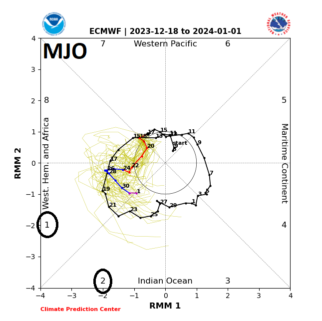
A teleconnection index known as the Madden-Julian Oscillation or MJO is expected to shift later next week into what are normally colder weather “phases” for the eastern and southern US. Plot courtesy NOAA, ECMWF
Unfolding pattern change
Over the next few days, an intense upper-level ridge of high pressure will intensify over the North Atlantic Ocean, but this will then tend to weaken as new ridging aloft develops over eastern/central Canada this weekend. This new area of high pressure ridging aloft will then tend to retrograde next week and become centered over west-central Canada in about a week or so on the western side of Hudson Bay. There will also be an extension of the newly placed upper-level ridging from west-central Canada down into the interior sections of the western US.
At the same time, an upper-level trough of low pressure is likely to intensify across the southeastern US with a second one deepening out over the northern Pacific Ocean to the south of the Aleutian Islands. The combination of all of these changes to the pattern at 500 millibars will be quite important in terms of the overall wind flow across North America. Specifically, this change should be more favorable for cold air masses to make their way from central and eastern Canada into the eastern and southern US and an active southern branch of the jet stream may bring increased chances for storminess across the Southeast US.

Other teleconnection indices known as the AO (top), NAO (middle) and PNA (bottom) tend to lead some support to the idea of a colder overall weather pattern for the eastern and eastern US by later this month. Maps courtesy weathermodels.com, NOAA, ECMWF
MJO, NAO/AO, PNA
A look at several teleconnection indices tends to support the idea of a colder overall pattern later next week in the eastern and southern US. The Madden-Julian Oscillation (MJO) appears to headed into “phases” that are typically more favorable for colder weather in the eastern and southern US. In addition, the Pacific North America (PNA) index is climbing into “positive” territory and should remain there for awhile and this is usually associated with high pressure ridging across western parts of the US and Canada. Finally, the North Atlantic Oscillation (NAO) and Arctic Oscillation (AO) which give us a clue as to the temperature and pressure patterns across the Arctic and North Atlantic are both forecasted to decline from “positive” levels to “negative” values which is usually associated with high-latitude blocking aloft such as what appears to be setting up for later this month across Canada.
Stay tuned…we’ll continue to monitor the prospects for an important pattern change in coming days that could result in more winter-like weather across the eastern and southern states.
Meteorologist Paul Dorian
Arcfield
arcfieldweather.com
Follow us on Facebook, Twitter, YouTube
Video discussion: